
Breaking News
Person of interest is identified in multiple child abduction attempts in BenGil area
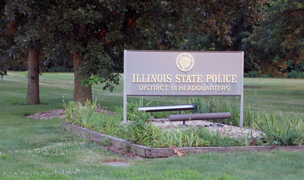
The Illinois State Police are investigating reports of multiple attempted child abductions in Benld and Gillespie that occurred over the weekend of July 4.
Trooper Yenchko with the Illinois State Police announced Tuesday afternoon that a person of interest has been identified and is cooperating with the ongoing investigation.
The first report came from Gillespie on Saturday, July 5 around 10 p.m. when a white male tried to lure a child out of his fenced back yard. It took place on First Street when the young child was watching fireworks. He immediately told his father, who came out, but then the male drove away in a truck.
The Gillespie Police Department was immediately notified and officers responded, but were unable to trace the vehicle.
The second report came in on Sunday, July 6 from Seventh Street in Benld around 3 p.m. after a male was trying to attract a young child out of his yard and toward his truck by waving him over. After parents heard their child screaming, they came outside to discover a gold truck driven by a white male, but the truck immediately drove off.
Officers with the Benld Police Department responded, but again were unable to track down the gold vehicle. Benld Police Chief Jim Zirkelbach Jr. told us he decided to turn the investigation over to the Illinois State Police after the report from Benld because the case covered multiple jurisdictions.
According to press releases from the Illinois State Police, the person is a thin white male approximately 5’8” driving a late 90’s Ford pick-up truck with a lawn mower in the bed of the truck.
This is not the first attempted abduction in the area. On June 22, the Gillespie Police reported a vehicle parked near the bike trail entrance tried to lure a child by asking him if he wanted to ride with him to buy a puppy.
There were also reports that another abduction attempt was made over the weekend on South Hardroad in Benld, but Chief Zirkelbach Jr. did not comment on that report.
– – – – – – – – – – – – – –
There are plenty of ways to keep up on BenGil news:
Sign up for our weekly email newsletter
Follow us on Twitter for the fastest breaking news updates and score updates
Comments


Another major winter storm is forecasted to blanket the BenGil area in heavy rains, flooding and snowfall starting Wednesday night through Thursday.
The mixture of precipitation and rapidly changing weather likely will produce the potential for sudden icing on roads, with high winds leading to blowing snow and reduced visibility.
“The Illinois Department of Transportation’s snow-and-ice teams will be prepared and out in force, but the public needs to be ready for conditions to change quickly and worsen if they are out on the roads,” said Illinois Transportation Secretary Omer Osman. “As always during periods of extreme weather, the safest option is to postpone any unnecessary trips and stay home. If you must travel, prepare for very slow and potentially hazardous conditions. And please slow down around our plows and other emergency vehicles, giving them plenty of room to do their jobs.”
The National Weather Service is predicting a wintry mix of precipitation to start with thunderstorms and heavy rain in much of the state this evening, converting to freezing rain overnight before turning to snow Thursday morning. In addition to localized flooding, ice and sleet accumulations are likely, creating extremely slippery surfaces and slick conditions.
Due to the rainy conditions ahead of temperatures falling overnight, the effectiveness of pretreating and salting surfaces in advance of significant snowfall will be limited. The public should anticipate icy conditions even when roads appear clear and greatly reduce speeds.
“As the Illinois State Police plans to take on the unpredictable Illinois weather, we would like to remind motorists to do their part in keeping the roads a safe place,” said Illinois State Police Director Brendan F. Kelly. “ISP, alongside IDOT and other agencies, will be working in hazardous weather conditions. Please remember to slow down, stay vigilant and move over for ANY vehicle on the side of the road.”
Statewide, IDOT has available more than 1,800 trucks and equipment to plow, treat roads and respond to weather emergencies. If you encounter a plow or any maintenance vehicle during your travels, please slow down, increase your following distance and remain patient. Do not attempt to pass – conditions in front of the plow will be worse than behind it.
Comments

Police are investigating the death of a Bunker Hill woman who was found dead at the end of her driveway near the roadway on Monday morning, January 31.
Nancy Blycker, 91, had multiple injuries and was pronounced dead at the scene, according to police. The Macoupin County Sheriff’s Office received a 911 call to the 2900 block of Wood Hill Lane around 7:40 a.m. on Monday.
The initial suspicion was homicide, according to a release by the Major Case Squad of Greater St. Louis who said approximately 20 investigators were working the investigation, but the autopsy contradicted that suspicion.
The Major Case Squad said on Tuesday it is “highly unlikely” Blycker’s death was the “result of homicidal means.”
The Major Case Squad turned the case back over to the Macoupin County Sheriff’s Department. The official cause of death is pending further lab analysis.
Comments
The National Weather Service has issued a Winter Storm Warning for the BenGil area, southwestern Illinois, and the St. Louis area.
The warning was issued early Tuesday taking effect at midnight tonight until noon on Thursday, February 3 calling for a “wet, heavy” snow. The forecast also calls for ice prompting a warning about possible power outages.
“All indications continue to point to a disruptive, impactful, and dangerous winter storm impacting the region starting late tonight and lasting through Thursday night,” the National Weather Service said in its Area Forecast Discussion.
The BenGil area is expected to receive heavy mixed precipitation including snow accumulations between 6 and 10 inches, sleet accumulations around three-quarters of an inch, and ice accumulations around two-tenths of an inch. Wind gusts will be as high as 35 mph on Thursday.
The storm is expected to start with rain most of the day today before transitioning into a mixture of freezing rain and/or sleet Tuesday night, then all snow Wednesday morning or as late as Wednesday afternoon continuing until about noon on Thursday.
Comments


-
 Community News4 days ago
Illinois treasurer to help Macoupin County residents reclaim $8.6 million in unclaimed funds on May 13 at Gillespie Library
-

 Community News5 days ago
MCHS slates drive-through dinner on May 13
-

 Obituaries5 days ago
Obituary of Mathew Dwayne Spickerman
-

 Obituaries4 days ago
Obituary of Roberta “Bobbi” Haneghan