
Breaking News
Two Coffeen residents arrested for multiple controlled substance charges
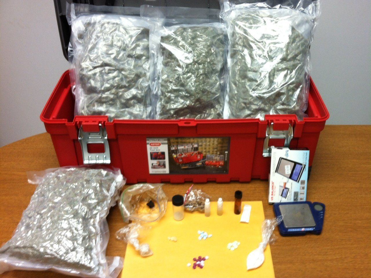
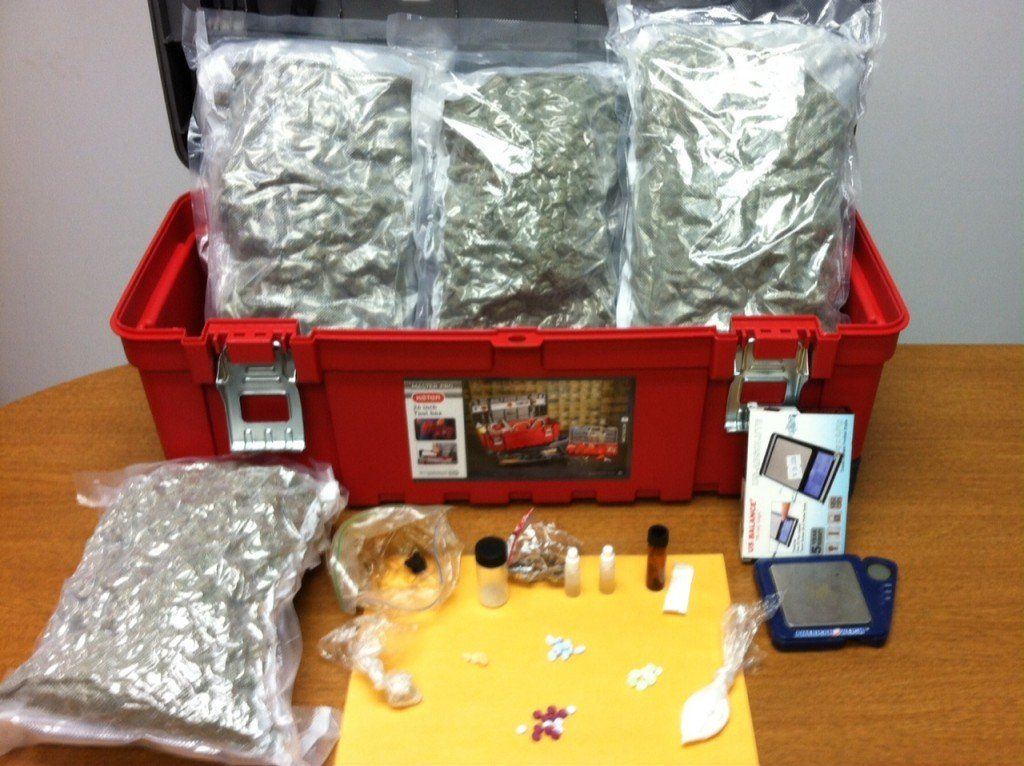
On October 11, 2013 the South Central Illinois Drug Task Force (SCIDTF) and Montgomery County Sheriff’s Office (MCSO) arrested two rural Coffeen residents for multiple controlled substance and cannabis charges.
The SCIDTF was contacted by the U.S. Postal Inspectors Office with information about a package being shipped to 926 Red Ball Trail, Coffeen. MCSO K9 unit conducted a free air search of the package resulting in a positive alert for cannabis or a controlled substance.
The U.S. Postal Inspectors and SCIDTF conducted a controlled delivery of the package to the address in Coffeen which led to the arrest and seizure of several different types of illegal drugs and two arrests.
Bryan A. Richardson, 27, and Jessie M. Richardson, 29, husband and wife from the Coffeen address were placed into custody. The following alleged illegal drugs were seized during the search of the residence: LSD, psilocybin mushrooms, opium, MDMA, multiple controlled substance pharmaceuticals: oxycodone, vicoden, morphine and approximately 6.5 pounds of cannabis.
Each subject were processed into the Montgomery County Jail and charged with cannabis trafficking and possession with the intent to deliver controlled substances. They are being held in jail pending formal charges by States Attorney Chris Matoush and a jail bond to be set.
– – – – – – – – – – – – – –
There are plenty of ways to keep up on BenGil news:
Sign up for our weekly email newsletter
Check out all of our pictures on our sister site, we are your personal photographer
Like us on Facebook for a slightly different take
Follow us on Twitter for the fastest score updates and breaking news updates
Comments


Another major winter storm is forecasted to blanket the BenGil area in heavy rains, flooding and snowfall starting Wednesday night through Thursday.
The mixture of precipitation and rapidly changing weather likely will produce the potential for sudden icing on roads, with high winds leading to blowing snow and reduced visibility.
“The Illinois Department of Transportation’s snow-and-ice teams will be prepared and out in force, but the public needs to be ready for conditions to change quickly and worsen if they are out on the roads,” said Illinois Transportation Secretary Omer Osman. “As always during periods of extreme weather, the safest option is to postpone any unnecessary trips and stay home. If you must travel, prepare for very slow and potentially hazardous conditions. And please slow down around our plows and other emergency vehicles, giving them plenty of room to do their jobs.”
The National Weather Service is predicting a wintry mix of precipitation to start with thunderstorms and heavy rain in much of the state this evening, converting to freezing rain overnight before turning to snow Thursday morning. In addition to localized flooding, ice and sleet accumulations are likely, creating extremely slippery surfaces and slick conditions.
Due to the rainy conditions ahead of temperatures falling overnight, the effectiveness of pretreating and salting surfaces in advance of significant snowfall will be limited. The public should anticipate icy conditions even when roads appear clear and greatly reduce speeds.
“As the Illinois State Police plans to take on the unpredictable Illinois weather, we would like to remind motorists to do their part in keeping the roads a safe place,” said Illinois State Police Director Brendan F. Kelly. “ISP, alongside IDOT and other agencies, will be working in hazardous weather conditions. Please remember to slow down, stay vigilant and move over for ANY vehicle on the side of the road.”
Statewide, IDOT has available more than 1,800 trucks and equipment to plow, treat roads and respond to weather emergencies. If you encounter a plow or any maintenance vehicle during your travels, please slow down, increase your following distance and remain patient. Do not attempt to pass – conditions in front of the plow will be worse than behind it.
Comments

Police are investigating the death of a Bunker Hill woman who was found dead at the end of her driveway near the roadway on Monday morning, January 31.
Nancy Blycker, 91, had multiple injuries and was pronounced dead at the scene, according to police. The Macoupin County Sheriff’s Office received a 911 call to the 2900 block of Wood Hill Lane around 7:40 a.m. on Monday.
The initial suspicion was homicide, according to a release by the Major Case Squad of Greater St. Louis who said approximately 20 investigators were working the investigation, but the autopsy contradicted that suspicion.
The Major Case Squad said on Tuesday it is “highly unlikely” Blycker’s death was the “result of homicidal means.”
The Major Case Squad turned the case back over to the Macoupin County Sheriff’s Department. The official cause of death is pending further lab analysis.
Comments
The National Weather Service has issued a Winter Storm Warning for the BenGil area, southwestern Illinois, and the St. Louis area.
The warning was issued early Tuesday taking effect at midnight tonight until noon on Thursday, February 3 calling for a “wet, heavy” snow. The forecast also calls for ice prompting a warning about possible power outages.
“All indications continue to point to a disruptive, impactful, and dangerous winter storm impacting the region starting late tonight and lasting through Thursday night,” the National Weather Service said in its Area Forecast Discussion.
The BenGil area is expected to receive heavy mixed precipitation including snow accumulations between 6 and 10 inches, sleet accumulations around three-quarters of an inch, and ice accumulations around two-tenths of an inch. Wind gusts will be as high as 35 mph on Thursday.
The storm is expected to start with rain most of the day today before transitioning into a mixture of freezing rain and/or sleet Tuesday night, then all snow Wednesday morning or as late as Wednesday afternoon continuing until about noon on Thursday.
Comments


-
 Community News4 days ago
Illinois treasurer to help Macoupin County residents reclaim $8.6 million in unclaimed funds on May 13 at Gillespie Library
-

 Community News5 days ago
MCHS slates drive-through dinner on May 13
-

 Obituaries5 days ago
Obituary of Mathew Dwayne Spickerman
-

 Obituaries4 days ago
Obituary of Roberta “Bobbi” Haneghan