
Community News
Legacy maps of Gillespie on display at Gillespie Library

The Gillespie Public Library has added to its permanent collection a series of Sanborn Maps. Sanborn Map Company created maps of US cities in the 19th and 20th c. to allow fire insurance companies to access their total liability in US cities.
The maps take sections of the city and code them into different types of structures. Some blocks are quite detailed, especially the downtown areas.
The library has on display these maps until late July. The 5-map series are: (the below maps cover selected areas of town)
- 1894- 2 maps
- 1899- 3 maps
- 1906- 3 maps
- 1913- 4 maps
The most detailed is the 1925 maps that are in a booklet consisting of 18 maps that cover the entire city in 1925. This is the most interesting because we are now approaching the 100-year anniversary of the city at that time and your “old house or property” is probably on it.
For any questions, call the Gillespie Public Library at 839-3614
Comments


Members of the Community Unit School District 7 Board of Education on Wednesday night approved a package of four capital improvement projects totaling more than $160,000 in value. Work will start on the projects after the end of the current school year and is expected to be completed before the start of the 2026-27 academic year in August.
The board met on Wednesday night after Monday’s inclement weather forced the district to reschedule the board’s regular monthly meeting.
The board approved entering into a contract with Fisher Tracks, Boone, Iowa, to resurface the district’s all-weather track at a cost of $105,209. Supt. Shane Owsley told the board the district will use about $50,000 from an all-weather track activity fund, with the remainder to be paid with proceeds from an alternate revenue bond issue approved last year for capital improvements.
Great Western Abatement, Jerseyville, was retained to remove flooring containing asbestos from the choir room floor and middle school gymnasium school at a cost of $40,700. Great Western’s bid was the lowest of seven bids, ranging up to $65,000, submitted for the work. Additionally, the district is paying $8,900 to Reliable Environmental Services, Springfield, for engineering and design work associated with the asbestos removal.
All-purpose rubberized flooring material will be installed on the middle school gym floor by Dynamic Sports Construction, Leander, Texas, at a cost of $51,424.
For the first time in a number of years, the high school gymnasium floor will be sanded and refinished with new artwork. Blast Technologies, St. Louis, was hired to sand the 4,200-square-foot floor at a cost of $5,250. Designs Unlimited, Pinckneyville, will paint game lines and logos on the floor before sealing it with a clear stain at a cost not to exceed $18,738.
The board also accepted a bid of $33,890 from DeLaurent Construction, Wilsonville, to resurface the 118,700-square-foot parking lot at Benld Elementary School.
Though no action was taken, Board President Mark Hayes reported that the Building and Grounds Committee had directed Owsley to investigate the cost of replacing the CUSD 7 administrative building.
“This building is very much in need of replacement,” Hayes said. “It’s beyond its time.” During Monday’s torrential rainfall, Hayes said water came in through windows and water seeped in under the sill plate, bringing displaced nightcrawlers into the building. Staff members ran fans after the storm in an effort to dry out the interior.
According to Hayes, the school has been in contact with the local Baptist Church to investigate the possibility of acquiring the former Trinity Baptist Church for use as an administrative building. Church officials, however, have not yet made a decision about the fate of the former sanctuary after Gillespie’s two Baptist churches merged.
Owsley said the current administrative building comprises about 6,000 square feet. Current estimates are $400 per square foot for new construction which would translate into about $2.5 million to replace the administrative facility. The district might be able to shave some dollars off that estimate by reducing the size of the building.
“There’s a lot of unusable space in this building,” Owsley said, suggesting a more efficient floorpan could reduce cost. He also mentioned the possibility of a basement to provide storage space for outdated documents.
In addition to construction costs, Owsley noted, the district would be responsible for tearing down the existing building.
“I have no idea what’s in this building,” Owsley said, raising abatement concerns. “I’m guessing disposal of this building is going to be expensive.”
Hayes said Kevin Wills, the district’s bond issue advisor, will attend the June board meeting to discuss the possibility of refinancing some existing bonds to free up enough revenue to build a new administrative building. The administration currently is housed in a “temporary” structure that has served as the administration building for several decades.
MINE SUBSIDENCE STUDY
After several minutes of discussion, the board took no action in relation to entering into a contract with Marino Engineering and Associates to assess the district’s risk for incurring damage from a mine subsidence event. Owsley said existing maps show that portions of Gillespie Middle School are undermined. While the high school is not undermined, a major subsidence would likely damage the high school as well as the middle school. In recent months, more than one residential home on Elm Street near the school property has experienced damage from mine subsidence.
Marino’s $94,000 Phase I proposal would “determine the likelihood of something happening to one of our buildings,” Owsley said. The problem is that too much information could negatively impact the district’s ability to purchase subsidence insurance. “Information is great until it’s not.”
The district currently pays about $300,000 for mine subsidence insurance on the middle school, high school and vocational arts building. The school carries no subsidence insurance on BenGil Elementary because mine shafts under the building were grouted before the school was built.
“If we find out there’s not a major concern,” Owsley noted, it could reduce the district’s subsidence insurance costs.
On the other hand, if the study reveals a high risk of experiencing mine subsidence, the insurer could drop the district at the end of the current policy’s term. With only two companies in the country offering subsidence insurance, the district could end up with no insurance at all to cover damage from mine subsidence.

The only way to avoid that scenario would be to implement whatever options Marino might recommend to reduce risk. Those recommendations would likely include grouting (backfilling) mine shafts under the middle school. Grouting for the elementary school cost $4 million. To grout under the middle school would likely run as much as $6 million or more.
The only way the study would make sense, Owsley suggested, would be if the district was “comfortable making the corrections the study is going to make.”
Moreover, $94,000 would cover only a preliminary assessment.
“To get a full understanding of what’s going on underground, we’d be looking at a half million dollars,” said Owsley.
The issue was allowed to die when no board member moved to consider the contract.
COMMUNITY SOLAR PARTICIPATION
On a motion by Bill Carter, seconded by Weye Schmidt, the board voted unanimously to enter into a contract with Summit Ridge Solar to participate in a community solar project. Under terms of the 15-year contract, the district will realize a 13 percent savings on electrical power bills. The contract is automatically renewable for five years unless the district chooses to withdraw.
“Illinois provides a number of incentives for using solar,” Owsley said. “However, not everyone likes the look of having solar panels on their property. This will get us the benefits without putting up solar panels on our property.”
Summit Ridge’s proposal was the most lucrative of the proposals the district received. Other companies offered shorter terms with savings of five percent.
After 20 years, it’s likely the savings would drop to five percent. Owsley said he was told the district was better off going with the longer contract to get 13 percent in savings for as long as possible.
The school district was able to secure such favorable rates, according to Owsley is because there is an issue with solar fields storing the power they generate. “Our main usage time is during their maximum production time.”
DISTRICT FOCUS
During a District Focus segment, the board recognized sophomore Matrix Wright, whose art was the only entry from the United States included in the 2026 TOLI International Student Art Exhibition. The exhibition is a project of The Olga Lengyel Institute for Holocaust Studies in New York. The exhibit includes student art relating to themes associated with the Holocaust.
Wright’s work, entitled “An Immortal Continuum,” attempts to portray “the constant entrapment a Holocaust survivor might feel.”
Exhibition organizers received more than 250 entries from around the globe.
BUDGET PROCESS
On a motion by Peyton Bernot, seconded by Board President Hayes, board members voted unanimously to begin work on developing a district budget for fiscal 2027. Board members also approved a routine measure to permit expenditure of fiscal 2027 funds after July 1, pending approval of a new budget.
The school district’s fiscal year runs from July 1 to June 30 but new budgets typically are approved two to four months after the start of the fiscal year.
The current fiscal year’s $19 million budget was approved in September last year.
PERSONNEL
Following a one-hour executive session to discuss personnel and other issues, the board voted unanimously to approve the request of long-time middle school English and language arts teacher Kim Henderson, effective at the end of the 2028-29 school year.
Board members also voted unanimously to hire Andrew Crook as a first-year, non-tenured high school English teacher for the 2026-27 school year, pending documentation of certification and a routine background check. A graduate of Gillespie High School, Crook earned his teaching certificate at Illinois College, Jacksonville and for the past two years, he taught English at North Mac High School.
In separate actions, the board made multiple assignments to staff the district’s summer school program. Those hired include: Jessica Kelly as a middle school teacher, Ashlee Gibbs as a high school math teacher, and Jennifer Brown and Rob Macias as high school drivers’ education instructors. Each of the positions are contingent upon adequate student enrollment to offer the classes. In addition to academic staff, the board hired Andy Hirstein as a summer school food service worker.
The board voted unanimously to accept the resignation of Foli Seferi as high school paraprofessional and as assisted football coach. Both resignations are effective immediately.
In other personnel action, the board appointed Cate Plovich as the BenGil Elementary School yearbook sponsor, and appointed Josh Ross as a volunteer assistant football coach, pending documentation of certification and a routine background check.
OTHER ACTION
In other action, the board:
• Approved a mens highs school soccer coop with the Carlinville School District, with the provision Carlinville will dissolve the agreement if it pushes its program into a higher competitive classification.
• Approved an intergovernmental agreement with Lewis and Clark Community College under which the college will recognize some high school courses as college level credits.
• Approved early graduation requests for an undisclosed number of students, provided all graduation requirements are met.
• Approved renewing the district’s membership in the Illinois Elementary Schools Association.
• Approved the final calendar for the 2025-26 school year pending no further emergency days. Barring the use of emergency days, Monday, May 18 will be the last day of student attendance, with graduation ceremonies set at 2 p.m., Sunday, May 17.
Comments
One of the greatest annual events in American sports is the Saturday is the Kentucky Derby, which will be run for the 152nd time this Saturday. One past champion was bred in Macoupin County.
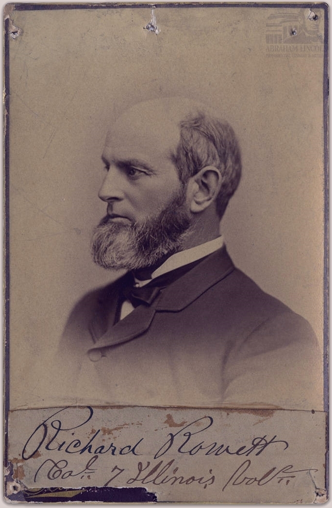
This week marks 137 years since the victory of Spokane, who captured the 1889 Kentucky Derby during the infancy of the event. The horse was bred at “The Meadows,” the farm of Gen. Richard Rowett one mile north of Carlinville.
Rowett horses, and their jockey colors of orange jacket and blue cap, were on tracks throughout the west and south. But Spokane was the greatest production of The Meadows, a nationally recognized breeding ground for thoroughbreds.
In 1885, a prized dark brown horse named Hyder Ali was standing at The Meadows when Rowett bred him to one of his top mares, Interpose. This pairing had produced favorable offspring in the past, including Grey Cloud, a fine racer owned by Noah Armstrong of the Doncaster Ranch near Twin Bridges in the Montana Territory.
Armstrong’s famous stable included such horses as Lord Raglan, the third-place finisher in the 1883 Kentucky Derby. When Rowett offered Interpose for sale late in 1885, Armstrong, familiar with the high quality of Rowett stock, purchased the pregnant mare and her suckling filly, Madelin, for the price of $1,000 and shipped the brood to Montana.
The Doncaster Ranch was known for its spectacular, three-story round barn that featured an indoor track. While in Spokane in the Washington Territory on business, Armstrong received word of the birth of Interpose’s colt. In honor of the city, he named the colt Spokane.
Spokane showed great promise as a two-year-old, winning two of five starts in 1888, and Armstrong entered him in the 1889 Kentucky Derby. Although a premier race, the Derby had not achieved the monumental status it enjoys today.
The race was run on May 9, 1889–a Thursday–in front of a crowd of 25,000, a fraction of the throngs that fill Churchill Downs today.
Home state favorite Proctor Knott was the overwhelming favorite at 1-to-2, while the relatively unknown Spokane was listed at 10-to-1 odds. That was enough for Frank James, brother of outlaw Jessie and a regular at countless tracks.
James, flush with a windfall of $2,400 from an earlier race that day, asked a bookmaker of the odds on Spokane. The reply was “Ten-to-one and the sky’s the limit.” James threw down $5,000 on Spokane, causing the bookmaker to reply, “As far as I’m concerned, that’s the sky!”
Under jockey Thomas Kiley, Spokane edged Proctor Knott by a head, setting a record at 2:34 ½ over the mile-and-a-half layout (it was changed to a mile and a quarter in 1896). He remains the only Kentucky Derby winner ever born in Montana.
Proving the win was no fluke, Spokane again beat Proctor Knott five days later at the Clark Stakes in Louisville. On June 22, Spokane won another key race of the era, the American Derby at Washington Park in Chicago, to become the first horse to win both races in the same season.
Back in Illinois, Rowett did not live to see the triumph of Spokane, as he died on July 13, 1887. His death was covered on page one of the New York Times the following day.
In addition to breeding, Rowett is also remembered as the first to introduce the true-bred beagle hound to this country from his native England. Prior to that, he was a Civil War officer and state politician.
The only horse actually born in Illinois to win the Kentucky Derby was the 1970 champion, Dust Commander.
Tom Emery of Carlinville, who wrote the award-winning biography Richard Rowett: Thoroughbreds, Beagles, and the Civil War, may be reached at 217-710-8392 or ilcivilwar@yahoo.com.
Comments

A former Carlinville High School football standout has signed as an undrafted free agent with the New England Patriots.
Kyle Dixon, a record-setting receiver at Culver-Stockton, an NAIA program in Canton, Missouri, inked the deal with New England after being passed over in the NFL Draft April 23-25.
Dixon was seen as an outside shot at being selected in the draft. He reportedly had visited at least one team, including Indianapolis, and was the subject of Internet speculation from various writers on his potential.
At Culver-Stockton, Dixon named to the American Football Coaches Association – NAIA All-American team. He was also a Heart of America Athletic Conference first team pick for the second straight year.
The 6-4, 216-pound Dixon was fourth in the NAIA with 83 receptions and third with 1,282 receiving yards in 2025.
New England advanced to last February’s Super Bowl, losing to Seattle.
It was the tenth Super Bowl appearance in the last 25 seasons for the Patriots, one of the NFL’s marquee teams over the last quarter-century.
New England won six Super Bowl titles in that span. The Patriots also played in the Super Bowl after the 1985 and 1996 seasons.
Though most undrafted free agents have an outside chance of sticking on NFL rosters, some future superstars began that way. Notable UDFAs include NFL Hall of Famers Kurt Warner, Warren Moon, Antonio Gates, Adam Vinatieri, and John Randle.
In 2025, eight NFL teams had at least three starters who had been UDFAs coming out of college.
The Patriots are known for their development of UDFAs. The franchise has had sixty starting players who were undrafted free agents from 2011-25, more than any other team in the NFL.
At Carlinville High School from 2015-18, Dixon finished in the top 20 in Illinois High School Association history in single-season receiving yards and touchdowns, career touchdowns, receptions, and receiving yards, and career interceptions on defense.
An all-state selection as a defensive back, Dixon was an all-South Central Conference pick as a receiver. He was also a two-time all-SCC pick in baseball.
Prior to Culver-Stockton, Dixon played baseball at SIU-Carbondale, SIU-Edwardsville, and Georgia Gwinnett College.
Dixon will try to become just the third Carlinville product to play in the NFL.
The others were Leland “Tiny” Lewis, who appeared in 14 games over the 1930-31 seasons with Portsmouth (now the Detroit Lions) and a now-defunct Cleveland franchise, and Mike Seyfrit, who played in 13 games for now-defunct franchises in Toledo and Hammond in 1923-24.
(Tom Emery may be reached at ilcivilwar@yahoo.com or 217-710-8392).
Comments


-
 Community News4 days ago
2025 Macoupin County final multiplier announced
-
 Community News4 days ago
Illinois’ role in American Revolution focus of discussion at upcoming MCHS program on May 4
-

 Community News3 days ago
MCHS slates drive-through dinner on May 13
-
Community News2 days ago
Illinois treasurer to help Macoupin County residents reclaim $8.6 million in unclaimed funds on May 13 at Gillespie Library